Today we announce the “bGeigies4Ukraine” initiative #bgeigies4ukraine
The reckless and dangerous actions of Russian troops at Ukrainian nuclear facilities, including at the Chornobyl Nuclear Power Plant (CHNPP) and the Zaporizhzhia Nuclear Power Plant (ZNPP), have caused fear and concern in Ukraine, in neighboring countries, and around the world. In response, Safecast, SaveDnipro, the Czech National Radiation Protection Institute (SÚRO), and the Chornobyl Radiation Ecological Biosphere Reserve have joined forces to provide up to date and accurate radiation monitoring in Chornobyl and other parts of Ukraine. This is an unprecedented initiative, prompted by an unprecedented need for credible and independent public information from a nation under military attack. A significant dataset has already been accumulated under this initiative, which we are now making public.
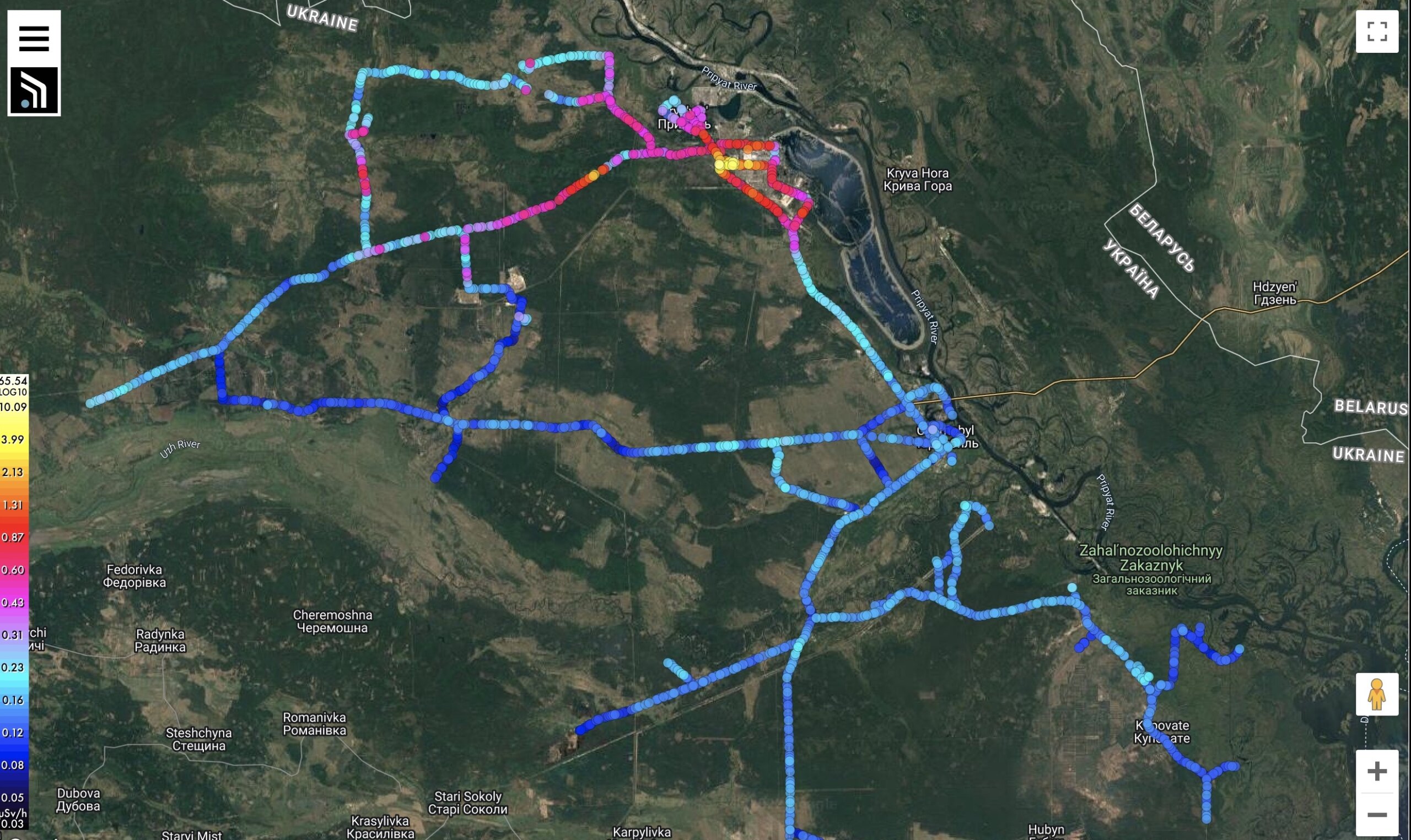
At the time of writing, the #bgeigies4ukraine dataset is the only public source of information about current radiation conditions broadly covering the Chornobyl region. Realtime monitoring is reportedly being conducted by local authorities, but that data has not yet been made available online. Similarly, the IAEA sent a team in late April, 2022 which took measurements in a limited area, but the data they have made public to date is sparse and not very informative — a single line in a 26-page report. The lack of independently verifiable official information has contributed to an atmosphere of mistrust. Safecast and its partners understand that the public expects and deserves a fuller and more transparent accounting of the environmental war crimes perpetrated in Ukraine by the Russian government, and this is our primary underlying motivation.
Preparation for the project began quietly shortly after Russian troops forcibly occupied the Chornobyl Exclusion Zone (CEZ) on February 24, 2022. We felt it was essential to provide any assistance we could to facilitate quick and open radiation monitoring once access to the CEZ was restored. As we have noted in previous blog posts, Safecast volunteers had collected a significant amount of radiation data from the Chornobyl region in the years prior to the invasion. This earlier data provides a useful baseline for comparison in order to identify whether or not Russian wartime actions caused any significant changes in radiation levels.

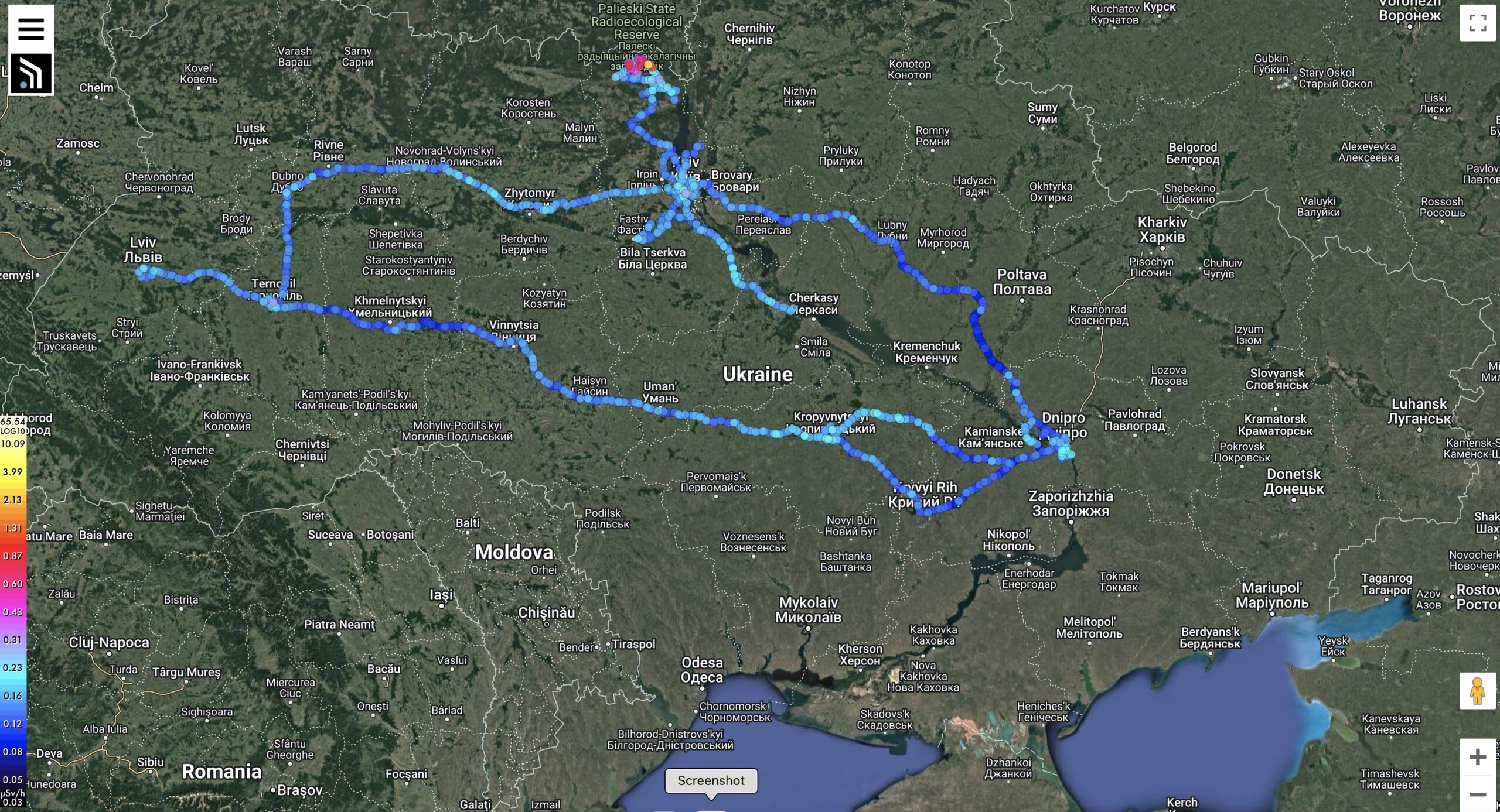
Invading troops left the Chornobyl area on March 31, 2022, and the first post-invasion Safecast data from the zone was published on May 3rd. A tricky logistical effort was mounted to send bGeigies from our colleagues in Prague to Ukraine and get them to the project participants there. Since then, #bgeigies4ukraine volunteers have been steadily and quietly mapping background radiation across the country. Thanks to these efforts, since May of this year over 90,000 new radiation data measurements for Ukraine have been uploaded to the Safecast database and online map, easily accessible to anyone anywhere in the world. This includes very informative data from the CEZ and other parts of Ukraine. Data collected from since May 5, 2022 can be viewed here. Data collection continues as we speak.
The purpose of Safecast is to gather radiation and other independently verifiable environmental data in ways which empower local people from many walks of life through their individual participation. This is the intent behind #bgeigies4ukraine as well, differentiating it from efforts begun so far by others. Participants in #bgeigies4ukraine include trained researchers, environmental scientists, data specialists, as well as drivers and other workers. Safecast is extremely grateful to have so many valuable colleagues who share our vision. Each participating institution contributes its considerable expertise to the initiative, and the many individuals involved share a forward-thinking resourcefulness and positivity. The project will continue for as long as necessary. In the coming weeks we will share more information about #bgeigies4ukraine and its key participants. We thank everyone for their continued support.

Participating organizations:

Czech National Radiation Protection Institute (SÚRO)


Chornobyl Radiation Ecological Biosphere Reserve
